An Educational & Gastronomical Tour of Northern California

Sunday, September 20, 2009

Day 9, September 18 - Old Sacramento

An extremely full day with many exciting adventures began as we carpooled to downtown Sacramento, the capital city of California. Old Sacramento (see www.oldsacramento.com/history) is a four block, 28 acre section along the Sacramento River. As the city moved east, this area was the worst skid row west of Chicago. In the 1960's it was redeveloped with wooden sidewalks, cobblestone streets, museums, restaurants and shops that preserve its historical character and it became the first historical district in the West.


Old Living History Program tour guide, "John F. Morse, MD, physician and surgeon of 1850", greeted us upon our arrival and proceeded to give us a most informative and enlightening history tour of his town. The group hung on every word as he dramatically told his story.


In 1839 John Sutter established Sutter's Fort at the confluence of the American and Sacramento Rivers. It grew and became a permanent settlement; but it wasn't until James Marshall discovered gold in 1848 and thousands came to seek their fortunes that Sacramento became a commercial and trading center. Many waterfront establishments were built and the City of Sacramento was born.

Throughout the early years flooding and fires destroyed the hastily built town. Eventually the buildings were rebuilt in brick and stone. In 1853 a gigantic project to raise the city was proposed but it wasn't until another devastating flood in 1862 that it was accepted. Within a few years thousands of cubic yards of earth were brought in on wagons and every building was raised an entire story. The original street level can be seen below the boardwalk sidewalks and what are now basements.

Dr. Morse explained how he had, as did many others, traveled from New York via ship to Panama where he rode a mule from east to west. He then boarded another ship which brought him to San Francisco and continued on land and water to Sacramento. The early days of panning for gold were very hard and not too profitable for him. Since he had a profession he opened his office and provided medical care for the growing population. He regaled us with stories about those first years, the hotels, the bath houses, the saloons (first one established when the first person stepped off the first ship), the bordellos, the theaters and the corrupt acts of the merchants and land barons. We visited stables and the Fire House which were still the original buildings. He told us about early millionaires who made their fortunes from either gold and or merchandising and the prominent Californians that had their start here. The California Steam Navigation Company was established to bring what was needed up the river from San Francisco. Old Sacramento was the terminus for the Pony Express from St. Joseph, MO. In 1869 the transcontinental railroad was completed and agriculture in the rich Sacramento valley became prominent. As we walked the streets of Old Sacramento we could see through his eyes and his stories what the people were like and how they lived their lives.


There are 27 museums and historic parks in the area including the California State Railroad Museum and the Wells Fargo History Museum. (See http://www.discovergold.com/) Today Sacramento is an important highway, rail and river hub and the marketing center for the rich agricultural region of the Sacramento Valley.


Following the tour of Old Sacramento, our private trolley transported us from the old days to the new days as we rolled across town to the State Capitol Building.


to be continued.................

Thursday, September 17, 2009

Day 8 Thursday, September 17 - Vinavigator


Today no one had to drive. We were picked up at the campground by a beautiful white luxury coach furnished by our guide Martin Raisman. Martin specializes in tours of the Sacramento wine region where there are 200 wineries, many award winning. Most of these wineries are considered artisan and boutique wines, producing 1,000 to 10,000 cases per year and are family run.

While enjoying Starbucks coffee and muffins, we drove through the countryside to Amador County about 45 miles southeast of Sacramento in the Sierra Nevada foothills. The terrain changed from flat lands (very brown and barren) to hills (still brown but with trees) Along the way we passed farms growing vegetables, pecan and almond groves and pumpkin patches. Many of the vinyards had huge clumps of grapes ready for harvest. There were numerous small communities, many not incorporated along the road. The area is becoming known for its beautiful scenery, great people and great wine.
Our first stop, however, was NOT at a winery but at the largest alpaca ranch west of the Rocky Mountains. As the big bus pulled into the driveway of the Retiredice Alpaca Ranch everyone let out a long "awww" when we caught our first glimpse of these beautiful, gentle creatures. Paige, the owner, talked to us about raising alpacas.

This ranch is for breeding and each "cow" has one cria (baby) per year after 11 1/2 months gestation. She has 70 animals one of which was born last night and another that was two days old. Entering the pen area where the older females and their offspring wandered, she told us
they were docile and loved people. If we knelt down, they would come over to investigate. Their wool is very soft and has no lanolin. Fully grown they weigh 150 to 180 pounds. They are sheared once a year in the spring so they are cool in the summer and warm in the winter. Tearing ourselves away from the animals, we visited her shop filled with hats, gloves, socks, sweaters, blankets, etc., all made from the alpaca wool. Several members made fashion statements with the hats.

Latcham Winery was the next stop of the day. It has been in operation since 1981 and has many award winning zinfandel wines, some produced from vines that are over 100 years old. It was our "task" to sample any of the 15 wines we desired (I managed 7 tastes) including the 2009 Best Zinfandel of California winner (a 2007 Special Reserve which many of us purchased). The vinyard was beautiful and the tasting room walls were covered with many ribbons and medals.


In addition to the wine, we were served "Margaret's Pass the Port Brownies" made with semi-sweet chocolate chips and port wine -- Heavenly!! She also provided the recipe.

Back to Sacramento we traveled, going beyond the city westward to the delta area of the Sacramento River. Our lunch stop (yes, we sampled wine before lunch) was in Clarksburg at Husicks Country Store which was in a building constructed in the 1800's. It had been a general mercantile with a post office, then a hardware store. Along with lunch was wine tasting.

Driving along the levee road following the river, we headed for our last stop at the Bogle Winery. It is the 13th largest winery in the country producing one million cases per year. There we relaxed and of course tasted more wines. It was interesting to hear the comparisons the wines we tasted in the hill country this morning with those we were now tasting in the delta low country


The big white coach wound its way through many back streets of downtown Sacramento to avoid the heavy traffic on the highways. Some MIM'ers took naps while others sat outside and talked about our day's activitie. Gene after wine tasting

Wednesday, September 16, 2009

Day 7, Wednesday, September 16 - Moving Day

It wasn't as cold this morning when we all got up to prepare for departure from our Truckee campground. Promptly at 10 am the "wagon train" proceeded west towards Sacramento. As we traveled over the mountain road on I-80 I thought about all the history we had learned surrounding the pioneers and their journey. How they struggled over mountain passes, through streams and rivers with wagons holding all their possessions hoping for a new and better life.

The scenery was breathtaking, filled with mountain peaks, mountain lakes, small hamlets and tall green forests. As we descended into the lower elevations, the landscaped changed to rolling hills with smaller trees of different types including numerous California live oaks. With a rude awakening we entered the outskirts of the big city with its bustling traffic. It certainly had been quiet and pleasant up in the mountains at Lake Tahoe. It made me realized that even back in the early 1900's those people who traveled to Lake Tahoe for escape from the city did it for the same reason we enjoy doing it now.


After settling in our campground in Sacramento California, the capital of California, at Cal Expo adjacent to the California State Fairgrounds, Dee gave us a short orientation meeting. Terry Selk, Director of Tourism for Sacramento and Nick Leonti told us about the many activities available in the Sacramento area as well as interesting facts about the different wine regions we would be visiting. They even brought samples for us from two nearby wineries. They are working on putting the Sacramento wine country on the map. Elevation dictates the the growing conditions for the grapes and the lower areas are better for reds. The foothills have more white wines. During our four day visit we will experience these changes. The elevation of Sacramento is 52 feet. At Truckee the elevation was 5840 feet, so we have come down quite a bit. The weather will be much different too. It's going to be in the 90's during the days.


Our car caravan headed east to Amador County and the town of Plymouth. Leaving the city we first passed flat open lands, then came to the foothills and more trees. One community was filled with horse ranches and equestrian areas. Our Sacramento area gourmet dinner was presented to us at the Taste Restaurant owned by Tracy Berkner and her husband Mel who is the chef. The restaurant is open five days a week and the waiting list is months long for a weekend reservation. See www.restauranttaste.com They opened especially for our group with a choice of two main dishes: Wild Mexican Prawns and Iowa Pork Loin, each prepared in a special manner. Our appetizer was fresh figs stuffed with a special bleu cheese and a small amount of balsamic vinegar. The three different kinds of fresh baked bread were outstanding (I had to sit on my hands to stop eating it). An unusual salad of heirloom tomatoes and two kinds of fresh green beans followed. Dessert choices were chocolate decadence or vanilla bean gelato. Both were yummy!! The food, presentation and service were outstanding and the local wines were wonderful. A surprise glass of Black Muscat accompanied our dessert and coffee.

Tracy is also the president of the County Tourism Bureau and gave us an insight into the wine making families and their businesses. The town grew during the gold rush due to the lumber mills that were needed to send to the mines. Now it is mostly an agricultural area where some of the premier grapes of Northern California are grown for the 40 wineries in the county in addition to sending grapes to Napa. The people are a close knit group and always helping each other.

Tuesday, September 15, 2009

Day 6 Tuesday, September 15 - Free Day

Almost everyone slept in today as we had no scheduled activities. Most of us caught up on cleaning and laundry and grocery shopping. Some had repairs to do to their coaches. Others went out exploring areas we did not get to or returned to areas they wanted to see again. John Ham went geocaching.

At 5 pm we gathered for "happy hour" and enjoyed exchanging stories and the camaraderie of the group.

Monday, September 14, 2009

Day 5, Monday, September 14 Virginia City


Virginia City: (From AAA) With 30,000 residents and more than 100 saloons the Virginia City of the 1870's was the West's mining metropolis. The Comstock Lode had given the town unequaled prosperity. The ore extracted had an estimated value of at least $232 million, some of which was used to build San Francisco. Notable residents included Mark Twain and Bret Harte who were reporters for the Territorial Enterprise, Nevada's first newspaper. Much as been done to restore Virginia City to its 1870 boom town appearance.


Gold Mine Trolley Ride

We set out by carpool at 9AM for Virginia City, Nevada. It was cool and sunny, and we all looked forward to our "mines" day. Passing the Geiger Summit (6789 feet elevation) we began the decline to Virginia City (6200 feet). Our auto caravan arrived at 10:15AM, parked and visited the Mark Twain Museum. After the museum we were on our own until lunch at Rick’s Hungry Miner.Trolley ride

Don Harton, fellow Monaco owner narrated the tour at the Mark Twain museum


We were each given a Virginia City pass and were on our way! The Trolley and train rides were narrated and gave an in depth review of the area. The trolley gave a 20-minute trip around the town, while the 35-minute train ride concentrated on local mining history and sites. The Way It Was Museum presented pictures, videos, lithographs and models of Comstock history. The historic Fourth Ward School and Museum and the Comstock Gold Mill were popular destinations. One of my favorite destinations was the Piper’s Opera House. This narrated tour created visions and auras of an elegant near past. Although it is in the process of restoration, the opera house is filled with the memorabilia of famous stage personalities from the late 1800’s through the mid 1900’s.

Stan and Barb Jones and Gerri Cederholm waiting for the Train Ride

Beautiful church steeples rose above the mountain-crested skyline of this city that sits atop the Comstock Lode. Thought provoking cemeteries, buildings that survived the 1880’s fires, and many other sites made this a memorable trip.
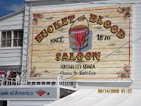
It would not be a complete tour of Virginia City without visiting one of the many saloons in the heart of the city. We picked one that had a very large window giving us a lovely view of the city and surrounding area. Most of us set out to make stops for dinner in Reno or just return to the RV Park.

Day 4, September 13 - Drive Around Lake Tahoe

At 8:30 on the dot, the car caravan left the campground to begin our 72 mile drive around Lake Tahoe.


A brief History of the area: Washoe Indians inhabited the area for 10,000 years. They mainly camped on the shores of the lake in the summer while hunting, fishing, feasting, trading, socializing and preparing food for the winter. They took what they gathered and went down to the warm valley for the winter. On February 14, 1844, John C. Fremont with scout Kit Carson arrived while searching for a route across the Sierra Nevadas. For many years people just passed through the area until the 1849 discovery of gold and then the silver discovery in the 1850's. Timber was necessary for the shoring of the silver mines. The loggers clear cut the area around the lake. The beautiful pine forests we now see is a second growth with many of the trees over 100 years old. By the early 1900's the rich began coming to Lake Tahoe for summer retreats, hotels and homes were built. The west side of the lake is more inhabited and privately owned because before the roads were built the railroad brought people and supplies to Truckee, wagons went from Truckee to Tahoe City. From there steam ships carried them to stops along the shore. Roads were paved in the 1920's and 30's, more people arrived and now tourism is the main industry. The east side of the lake is most public land consisting of State Parks and National Forests. In the winter the entire landscape is is covered by snow. An average of 125 inches covers the shore and as much as 300 to 500 inches in the mountains, thus the great downhill and Nordic skiing. The lake never freezes due to the constant exchange of water from the bottom to the surface.

Driving along scenic Highway 89 we passed the entrance to Squaw Valley Ski Area, the site of the 1960 Winter Olympics. There are many things to do n the lake area which boasts 22 ski resort areas, 23 golf clubs and 11 marinas not to mention all the biking and hiking trails, fishing, kayaking, windsurfing, boating, sailing, water skiing, horseback riding and swimming.

Turning south on 89 along the shoreline at Tahoe City was a dam which controls outflow at Tahoe City, we passed through many small communities dotted with summer home and cottages, shops and restaurants. Evidently there was a bicycle race today around the lake. Thank goodness the hundreds of bikers were going the other way and were on the other side of the road. The estate of Henry J. Kaiser was built in 1935 on the lakeside of the road and served as the site of the Mafia family's home in the movie "Godfather II".


Our first tour was at Sugar Pine Point State Park where Pine Lodge, the 11,000 square foot Hellman-Ehrman Mansion stands. The 3 story Queen Anne style home designed by architect Walter Danforth Bliss was built by Isaias Hellman, a west coast banker. It was completed in 1902 and has 11 bedrooms. In 1920 daughter


Florence Ehrman inherited it. In 1965 it was sold to the State of California and became a state park. The tour guide was excellent and told us numerous stories about the history of the home and the families who occupied it. Besides the main house the 1016 acre estate encompasses a caretakers cottage, carriage house, 2 boat houses, ice house, butler's house, maid's quarters and children's house. Also on the property is the Phipps Cabin which was homesteaded in 1860 by a Kentucky frontiersman who called himself a General even though he wasn't one. The Visitor and Nature Center has displays of many of the plants and animals of the area and lake facts. The dense forest consists of white and red firs, cedars, jeffrey pines, sugar pine, ponderosa lodgepole pine, quaking aspen and black cottonwood.

Our official Photographer, George Cederholm The whole gang:
Front row: Linda Barron, Joann Bush, Rita Ham, John Ham, Susie Walsh, Barb McCray, Dee Irwin, Barbara Jones, Geri Cederholm.
Back Row: Gene Barron, Bill Beckley, Bud Walsh, Wayne McCray, Clare Law, Jim Law, Tom Irwin, Stan Jones, George Cederholm.


Following our tour, we posed for group picture in our MIM shirts on the shores of the lake under the towering pines. By then it was lunch time and we gathered in the picnic area to enjoy our box lunches. The restroom in the area had six doors but only two were unlocked due to budget constraints. George and Gene waiting for restroom

Continuing our tour we passed Meeks Bay which was a fishing camp for the Washoe Indians. Then D. L. Bliss State Park where where the Old Lighthouse, Rubicon Point, one of the best beaches and one of the deepest point along the shoreline (1400') are located.

A stop at Emerald Bay was important so we could go to the overlook where we could again see the only island on the lake with its tea house and a glimpse of the Vikingsholm.


The scenic byway rose high above the lake and then we drove down to Taylor Creek Visitor Center operated by the US Forest Service and the headquarters for Lake Tahoe Basin Management Unit. A Ranger told us some facts about the low, marshy area along Taylor Creek. Following a 1/2 mile loop trail through the marsh and across the creek we observed the various foliage in this area that is quite different from the higher mountainside. An underground visitor center with a diversion of the creek that empties into Late Tahoe allowed us to watch the native fish.


Our last tour for the day was at the Tallac Historic Site where California's early days the rich and famous built elaborate summer retreats in the late 1800's and early 1900's. The area is in the largest grove of old-growth trees in the Lake Tahoe Basin (they really were huge and very very tall). This beautiful area consists retreats built by three prominent San Francisco families. The Baldwin Estate (1921) was once a hideaway for Elias J. "Lucky" Baldwin (founder of Santa Anita racetrack among other things), the Pope Estate (1894) haven to Lloyd Tevis and George Pope families the Heller Estate - Valhalla (1923) and the archaeological remains of the Tallac Resort (1890-1916). After a movie at the visitors center we toured the grounds and the Pope House which has been restored. The buildings included many cottages for the family's guests, the children's house, a laundry, dairy, barn and boathouse. There was also a wonderful arboretum with non-native plants, a pond and waterfall and gazebo.

Tom in the boathouse


Following this tour we were all on our own to continue the rest of the road around the lake. Going south and then east we passed through South Lake Tahoe, crossed the border into Stateline,Nevada which is lined with casino's and hotels. Further along Highway 50 is the turn off for Heavenly Ski Area (the other very prominent ski area on the Lake). Going around the bend we could observe the contrast between the heavily populated west side (which is the protected side) and the open, less populated east side. At Cave Rock, a sacred site to the Washoe Indians, has a huge cave where ceremonies took place. There is a tunnel that has been built through the mountain. Sand Harbor State Park has an overlook where you can walk down to the waters edge for a different lake view. At the northeastern curve is Incline Village and Crystal Bay where the north end casinos and hotels are located. The Cal Neva Resort has the state line going right through it.

A tired but happy group of explorers returned to the campground at various times this time satiated with magnificent vistas of the mountains, the forests and the lake.


Followers